1st Weekend Of November Will Feel More Like May In The Northeast

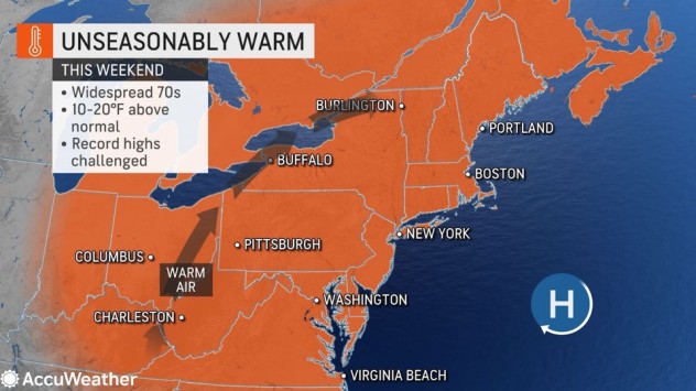
November kicked off with above-normal temperatures in much of the East, and AccuWeather meteorologists say that the thermostat will be cranked up even higher this weekend as temperatures challenge long-standing record highs.
Despite some rain to start the week, temperatures in the Northeast were above normal as the calendar flipped from October to November. Increased sunshine combined with a northward bulge in the jet stream will continue to promote unseasonable warmth into the weekend.
“Temperatures right through the weekend in locations such as New York City, Boston and Philadelphia will be more typical of late May, in the 70s F,” said AccuWeather Senior Meteorologist Carl Erickson.

Sunday’s predicted high in the upper 70s in Philadelphia is what residents would expect closer to Memorial Day weekend than in early November. A southerly wind flow ahead of a cold front could boost temperatures even higher, and the daily record of 79 degrees is certainly within reach.
It is a similar story in the Big Apple. The projected high in the mid-70s on Sunday is more common in the last week of May in New York City and could tie the daily record of 74 F set in 2015.
The warmth may be even more noteworthy in Boston. The daily record of 73 F is in jeopardy of being tied or broken on Sunday, a temperature that is more common for Boston during the opening days of June.
Elsewhere, high temperatures could approach the monthly record high of 82 degrees from 1961 on Saturday in Pittsburgh. The current AccuWeather forecast for Saturday in the Steel City has temperatures topping out right around the 80-degree mark.
Even though the days this time of year are shorter than in the late spring, overnight lows will be unseasonably high as well. With days starting out so warm, temperatures will not need to rise all that much for record highs to be challenged during the afternoons.
Unusual warmth this time of year is certainly not unheard of. Some locations such as Caribou, Maine, and Providence, Rhode Island, could challenge record highs on Sunday that were set just two years ago.
“Some locations will have the warmest start to November since 2020,” said Erickson.

A cold front may add a few extra clouds and a slight possibility of rain from northern New England southward through Pennsylvania, Maryland and West Virginia on Sunday. This may send Sunday temperatures slightly lower in those locations, but that won’t be the case farther east along the Interstate 95 corridor.
On Friday and Saturday, much of the East can expect high clouds to filter the sunshine a bit. These clouds could make for picturesque sunrises and sunsets and will do little to temper the warmth.
In parts of New England and the interior Northeast, there will be an additional factor that may further enhance the warmth.
“In locations where the leaves have fallen off the trees, more sunlight will be able to make it to the surface, allowing more warming of the ground and surrounding air,” Erickson explained.
This is also sometimes a factor in the spring, prior to the trees budding and getting their leaves. Although the sun angle is lower now than in the spring, the effect will be similar.
The cold front will largely fall apart by Monday and lead to a continuation of record-challenging warmth. By later next week, temperatures are more likely to fall shy of records. However, the above-normal warmth could continue through at least the end of next week.
Produced in association with AccuWeather.
The Western Journal has not reviewed this story prior to publication. Therefore, it may not meet our normal editorial standards. It is provided to our readers as a service from The Western Journal.
Truth and Accuracy
We are committed to truth and accuracy in all of our journalism. Read our editorial standards.
Advertise with The Western Journal and reach millions of highly engaged readers, while supporting our work. Advertise Today.


