Arctic Air To Send Temperatures To January-like Levels Across Central US

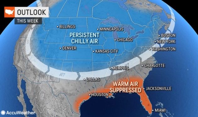
AccuWeather meteorologists are tracking a burst of Arctic air that will give much of the central United States a taste of mid-winter cold as temperatures plunge to their lowest levels yet this season — a staggering 20-30 degrees Fahrenheit below average.
Residents from Minneapolis to Chicago, St. Louis and Oklahoma City may be double-checking their calendars late this week as air that is even colder than what is considered “normal” for the middle of January envelops the region. Although chilly conditions and snow have already moved into many of these areas this week, AccuWeather’s experts say the coldest air is yet to come.
“Many places in the Plains and Midwest will experience high temperatures 5-10 degrees or more below what a typical mid-January day would be,” AccuWeather Senior Meteorologist Joe Lundberg said.

In Chicago, for instance, AccuWeather forecasters expect daytime temperatures to climb no higher than the middle to upper 20s Friday, while a normal high on Jan. 15 is 31.
“The last time Wichita, Kansas, had a high of 32 or lower was on March 10,” Lundberg said. AccuWeather’s latest forecast places the city’s maximum temperature for Friday right around 30 degrees.
Even locations farther south will not be spared from Old Man Winter’s early arrival. In Oklahoma City, following a wintry hit of rain and snow at the beginning of the week, temperatures will close out the week in the upper 30s. This is well below their lowest average high during the winter, which is in the upper 40s.

Adding an additional shock factor to the upcoming cold will be widespread wind gusts of 20-35 mph that will have residents reaching for extra layers to stay warm while going about their daily routines.
AccuWeather RealFeel® Temperatures may remain in the single digits throughout the day Friday in Minneapolis and could be no higher than 10 in Chicago. Across the northern Plains, these values may stay below zero for a portion of the daytime hours.
Those hoping to catch a glimpse of the Leonid meteor shower from Thursday night to early Friday will need to bundle up before heading outside, although clouds could obstruct the view for many in the North Central states.
In terms of how this cold wave stacks up compared to others during the month of November, experts say that more than a dozen record low maximum temperatures could be challenged Friday, including in St. Cloud, Minnesota; Kansas City, Missouri; Oklahoma City; and Topeka and Wichita, Kansas. A handful of daily overnight low records could also be in jeopardy.

Lundberg attributes the early-season cold bursts entering the northern tier of the U.S. to an area of high pressure building in Alaska over the next few days.
“The wind flow around this high drives multiple waves of cold air southward out of Canada into the middle of the country, with the coldest of these waves on tap for the end of the week,” Lundberg said.
The late-week cold wave will shift eastward by the weekend, leaving Northeastern residents to shiver in January-like cold as well. By that point, the most significant lake-effect snow event of the season so far is also likely to be fully underway across the Great Lakes.
For those not quite ready for a lengthy visit from Old Man Winter, Lundberg noted that a shift in the dominant wind direction throughout the atmosphere should allow the harsh chill to ease up by the Thanksgiving holiday next week.
Produced in association with AccuWeather.
The Western Journal has not reviewed this story prior to publication. Therefore, it may not meet our normal editorial standards. It is provided to our readers as a service from The Western Journal.
Truth and Accuracy
We are committed to truth and accuracy in all of our journalism. Read our editorial standards.
Advertise with The Western Journal and reach millions of highly engaged readers, while supporting our work. Advertise Today.


