Big Improvements In Air Quality Expected For Pacific Northwest

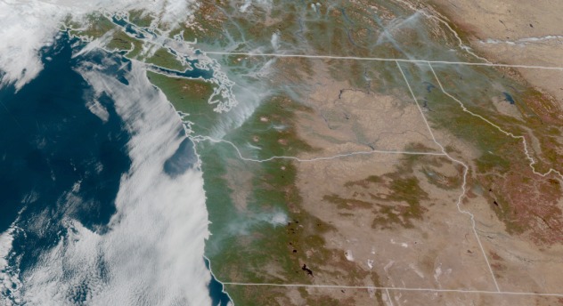
City skylines across the Pacific Northwest were blanketed in a smoky haze as wildfires across Oregon and Washington contributed to some of the worst air quality in the world this week.
AccuWeather meteorologists say the weather pattern that caused the air quality issues is finally breaking down, allowing the most significant rainfall in months to douse Seattle and Portland, Oregon, and whisk away the stagnant conditions.
Thursday marked the second day in a row that Seattle landed at the top of the charts for the poorest air quality across the globe as air quality alerts plastered the Interstate 5 corridor. The Emerald City surpassed Beijing and New Delhi which are typically at the top of the list for some of the highest levels of pollution on an average day.
“It’s making me dizzy,” Seattle resident Joe Dinkins told Reuters. “I usually walk around a lot, but I’ve been having to cut down my exercising and take the bus.”

The air quality index reached very unhealthy levels, one step down from the most severe “hazardous” level, in both Seattle and Portland on Thursday, meaning that the risk of adverse health effects is increased for all individuals, regardless of age or pre-existing conditions.
Local officials urged those in the Portland metro area to stay indoors and use air purifiers and filtered ventilation systems if possible. Individuals who did venture out to get some exercise or go about their daily routines were seen wearing N95 masks to protect themselves from the increased ozone and particulate matter in the air.

Video footage showed Seattle’s iconic Space Needle shrouded in an orange hue as the sun tried to peek out, while cars driving on a bridge appeared to disappear into a void as the roadway became clouded by the haze.
AccuWeather forecasters say an area of high pressure that has remained parked over the region throughout the week led to stagnant conditions. Underneath high-pressure areas such as this one, winds remain light, and precipitation is usually nonexistent. As a result, pollution from wildfires remains trapped close to the ground and causes air quality to worsen.
As of Friday, approximately two dozen fires were burning across Washington and Oregon, with most of the blazes concentrated in the highest elevations of the Cascades, according to InciWeb.
Fortunately for those longing to breathe better, the improvement in air quality began on Friday.
Behind a cold front, an onshore wind from the west will bring in cleaner air and precipitation from the Pacific Ocean into the weekend, which will slowly scour out the smoke. This will generally happen first in higher elevations and then more gradually in deeper valleys.
“The rain brought in by this storm will be much needed. Not only will it work to cleanse the air, but it could help douse some of the wildfires that have been the leading cause of this poor air quality,” said AccuWeather Meteorologist Adam Sadvary.

AccuWeather meteorologists expect around 0.50 of an inch to 1 inch of rain for the Seattle area when accounting for the rain arriving late this week and another round that is predicted for early next week.
As Sadvary mentioned, the rain is welcome regardless of its potential to help the fire and air quality situation. At Seattle-Tacoma International Airport, less than 0.50 of an inch of rain has fallen since the beginning of July. This is only 9% of normal over that timeframe (0.49 of an inch vs. 5.33 inches through Oct. 20).

Several ski resorts will also receive their first significant snow since last spring in the Cascade Range. Locales above 4,000 feet will experience the heaviest accumulations which will range from several inches to around a foot into this weekend.
This changing pattern in the Pacific Northwest will likely deliver another storm or two later in the new week, helping to keep air quality at improved levels.
Produced in association with AccuWeather.
The Western Journal has not reviewed this story prior to publication. Therefore, it may not meet our normal editorial standards. It is provided to our readers as a service from The Western Journal.
Truth and Accuracy
We are committed to truth and accuracy in all of our journalism. Read our editorial standards.
Advertise with The Western Journal and reach millions of highly engaged readers, while supporting our work. Advertise Today.


