Colder Air Setting The Table For Rounds Of Heavy Snow, Chilly Rain In The West

Rain and mountain snow will expand in scope across the western United States this week as a vigorous storm system ushers in some much-needed moisture for the region. AccuWeather forecasters say that while any rain and snow that falls across the West in the coming days will be beneficial to combat the ongoing drought, a few hazards can still arise.
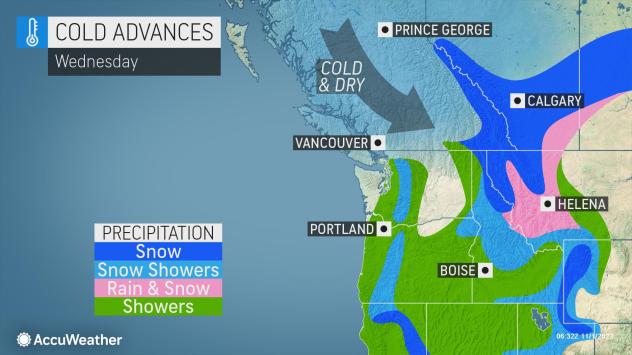
Snow began to fall at the highest elevations of the Pacific Northwest Monday night as rain dampened Halloween night festivities for portions of the region. Through Tuesday night, precipitation will continue to work its way south and east, eventually making it to places like Central California, eastern Oregon, Idaho and western Montana.
A significant dip in the jet stream over the western U.S. is set to develop Wednesday and bring a surge of colder air across the region. This colder air will not only cause temperatures to dip to about 5-10 degrees F below normal for a large swath of the West, but it will also work to send snow levels crashing down to near mountain pass levels.

“The Sierra Nevada is likely to bear the brunt of significant snow accumulations with over a foot possible late Tuesday into Wednesday,” AccuWeather Meteorologist Reneé Duff cautioned. Much of the snowfall will pile up over the course of six to 12 hours, possibly resulting in unsuspecting motorists becoming stranded, she added.
For areas closer to sea level, chilly conditions and wet weather will be the most noticeable impacts this week.
“Temperatures are poised to take a nosedive across the Western states as exceptionally chilly air for early November sweeps across the region,” Duff said. “For some, the air will be the coldest it has been since the springtime.”
Cities like Seattle are unlikely to get out of the 40s through at least Thursday, while Portland, Oregon, will struggle to hit 50 during the same time frame. Typical high temperatures for early November are the middle 50s and upper 50s, respectively, for each city.
Snow will continue to spread farther south and east Thursday and Friday as the storm pushes across the Rockies.

While the heaviest snowfall totals will remain confined to some of the highest elevations, a total of 6-12 inches of snow is not out of the question for portions of Utah, Wyoming and Colorado through Friday.
“Snow will reach the Four Corners states by late in the week and could result in Flagstaff, Arizona, picking up its first accumulation of the season,” Duff noted.
Flagstaff typically records its first measurable snowfall around Nov. 11, but its earliest on record was observed back on Sept. 19, 1965.
By week’s end, fresh powder is set to coat the slopes of many area ski resorts from the Cascades and Sierra Nevada to the Rockies, which could give these areas an early-season jolt for the impending ski season.
Forecasters say the storm responsible for the dreary start to November across the West will push out of the region by this weekend and head east. However, another powerful storm will be knocking on the doorstep of the West Coast by that time, aided by a surge of moisture from the Pacific Ocean known as an atmospheric river.
This push of moisture is likely to dump widespread rainfall amounts of 1-3 inches from western Washington to northwestern California.

“A new storm that rolls into the West this weekend to early next week will bring even lower snow levels than what occurs this week,” AccuWeather Senior Meteorologist Alex Sosnowski said. “Snow is likely to at least dip down to the hills around Seattle and Portland, and it is not out of the question that a few snowflakes mix in close to sea level in parts of western Washington and Oregon with this next storm.”
The forecast for early next week along the coasts of Washington and northern Oregon is an evolving one, according to Sosnowski. Air could become warmer which would mean less snow or it could become colder which could allow snow to fall just above and at sea level, he explained.
Accumulating snow is not the most likely scenario at this point for Seattle itself, and it is still rather early in the season to see snowflakes flying in the Emerald City.
The earliest measurable snow on record for the Seattle downtown area occurred more than 77 years ago on Nov. 7, 1945. The city typically sees its first accumulation in late December.
Seattle-Tacoma International Airport, located about 10 miles south of Seattle’s city center, sits about 250 feet higher in elevation than the city itself. At the airport, the earliest measurable snow on record occurred on Oct. 27, 1971.

Forecasters say an active, snowy pattern is set to continue for the northwestern U.S. next week with multiple storms headed for the region.
By the end of next week, travel for some popular mountain passes may become very difficult to navigate through, as feet of snow will cover elevated areas. Forecasters are even monitoring for some snow levels to come down as far as the valley floor for parts of the Northwest.
Produced in association with AccuWeather.
The Western Journal has not reviewed this story prior to publication. Therefore, it may not meet our normal editorial standards. It is provided to our readers as a service from The Western Journal.
Truth and Accuracy
We are committed to truth and accuracy in all of our journalism. Read our editorial standards.
Advertise with The Western Journal and reach millions of highly engaged readers, while supporting our work. Advertise Today.


