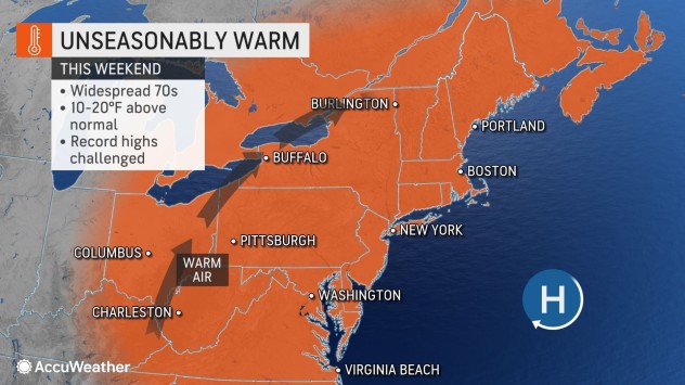
Cooler Air To Follow Spectacular Record-challenging Warmth In Northeastern US

Following a warm weekend with record-challenging temperatures for autumn outdoor activities, including the TCS New York Marathon®, cooler days are ahead next week starting on Election Day, AccuWeather meteorologists say.
High temperatures will be close to 20 degrees above average over a broad area of the mid-Atlantic, central Appalachians and New England into the start of next week.

Average highs in the Northeast for the period from Nov. 5-7 typically range from the mid-40s in northern Maine to the mid-60s along the shores of the Chesapeake Bay and the Delmarva beaches.
The annual TCS New York City Marathon® will take place on Sunday in conditions more typical of the middle of spring rather than late autumn. The marathon has been run since 1970 when the event was in September. Even though temperatures will fall short of the all-time marathon record of 93 degrees set on Sept. 4, 1973, the warmth and sunshine could take a toll on some runners.

“Temperatures into Monday in locations such as New York City, Boston, Washington D.C., and Philadelphia will be in the 70s F and more typical of late May,” said AccuWeather Senior Meteorologist Carl Erickson.
Daily record highs dating as far back as the pre-World War II era will be challenged. High-temperature records in Philadelphia, Boston and New York City on Monday were all set in 1938 and ranged from 76, 77 and 78 degrees respectively.
Temperatures are likely to fall a few degrees shy of all-time November records, which range from 83 in Boston to 86 in Washington, D.C., and Baltimore.
Aside from running a marathon, conditions may be close to ideal for travel and catching up on property maintenance before the winter sets in AccuWeather forecasters say. Breezy conditions may make leaf-raking activities a bit of a challenge from the Appalachians to the Ohio Valley, Great Lakes and New England this weekend. Much less wind is anticipated along the mid-Atlantic coast into Monday.

Conditions will begin to change from Monday over the Appalachians to the mid-Atlantic coast on Tuesday as cooler and more seasonable air settles into the region. A high-pressure area that had its origins from the southwestern U.S. will be replaced with a high-pressure area that originated in central Canada.
Highs starting on Tuesday, Election Day, will be an average of 15 degrees lower when compared to the weekend and Monday. However, despite the more seasonable temperatures, storms with rain and snow will avoid the region. Many locations can expect bright and sunny conditions on Election Day.

Meanwhile, AccuWeather meteorologists will be monitoring a broad area of disturbed weather off the southern Atlantic coast for tropical activity through next week. One or more tropical systems could brew over a zone encompassing 1 million square miles from Bermuda to the Bahamas and the eastern Gulf of Mexico.
At the very least, persistent breezes generated by the Canada high-pressure area to the north and the stormy zone to the south will lead to above-normal tides, coastal flooding and beach erosion from New Jersey on south from the middle part of next week to next weekend.

Late next week to the second weekend of November, a round or two of drenching rain may move up from the southern Atlantic coast and may be enough to lead to localized flooding and travel delays as well as provide a much-needed soaking in the Northeast.
Produced in association with AccuWeather.
The Western Journal has not reviewed this story prior to publication. Therefore, it may not meet our normal editorial standards. It is provided to our readers as a service from The Western Journal.
Truth and Accuracy
We are committed to truth and accuracy in all of our journalism. Read our editorial standards.
Advertise with The Western Journal and reach millions of highly engaged readers, while supporting our work. Advertise Today.


