'Endless Summer': October Heat Shatters Records Across The Parched Pacific Northwest

It has been nearly a month since the start of astronomical autumn and winter is right around the corner, but for millions across the Pacific Northwest, it still feels like summer.
The mercury started to rise last week and persisted through the weekend with temperatures falling just shy of the 90-degree mark in Portland, Oregon, and Seattle. Sunday’s high in Seattle topped out at 88 F, falling just 1 degree short of reaching the all-time October temperature record of 89 F set in 1987 and obliterating the previous daily record for Oct. 16 of 72 F that was set back in 2018.
The temperature in Portland did not quite get as high as it did in Seattle, but the duration of the record-setting warmth was more impressive. New daily high temperature records were set every afternoon from Wednesday, Oct. 12 through Sunday, Oct. 16, with Saturday being the warmest day of the bunch with a high of 87 F. Portland has tallied 12 days at or above 80 F this month, obliterating the previous October record of six 80-degree days set on multiple occasions, most recently in 1991.

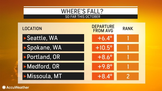
Spells of abnormally warm weather in recent weeks have made the first half of October the warmest on record, a stretch that AccuWeather Chief On-Air Meteorologist Bernie Rayno called “endless summer.” Temperatures have been averaging between 6 and 12 degrees above normal in Seattle and Spokane, Washington; and Portland and Medford, Oregon.
Not only was the weekend weather perfect for those who prefer summerlike weather, but also for folks who like chilly treats such as ice cream.
President Joe Biden made a quick stop for his favorite food at an ice cream parlor in Portland, Oregon, Saturday after campaigning for Democratic gubernatorial candidate Tina Kotek. Biden shook hands with the customers at the store before he ordered double dip chocolate chip in a waffle cone, according to Portland-based news station KATU.

While some residents enjoyed what might be the last of the summerlike warmth in 2022, the relentless heat paired with dry conditions continued to be an issue for crews battling wildfires across the Pacific Northwest.
The Cedar Creek Fire, the Double Creek Fire and the Moose Fire are the three largest wildfires currently burning across the region. Each has burned more than 120,000 acres as Monday morning. The Double Creek Fire, which is burning near the Oregon-Idaho border, is the largest of the three wildfires and has been active since lightning sparked the blaze on Aug. 22.
Smoke from these and other wildfires across the region is contributing to poor air quality, even in areas not located close to the fires. On Monday morning the air quality ranged from “fair” to “poor” along the Interstate 5 corridor, including in Portland and Seattle, and an air quality alert was issued for many areas west of the Cascades due to the reduced air quality. People sensitive to reduced air quality should limit the amount of time spent outdoors, experts say.
Temperatures will throttle back this week, and afternoon temperatures will be noticeably lower compared to the past weekend; however, highs will still be around 5 to 10 degrees above typical levels for mid-October.
An even bigger shift in the weather pattern is on the horizon for the Pacific Northwest, spelling an end to the current stretch of unseasonable warmth and making residents reach for their coats and umbrellas.
“A shift to a stormy pattern is expected at the end of this week into late October, which can bring multiple storm chances,” AccuWeather Meteorologist Alex DaSilva said. “This is likely to lead to above-normal precipitation and colder-than-normal temperatures, as well as high-elevation snow.”

Since the start of September, Seattle has received just 0.26 of an inch of rain, just 8% of what typically falls during that period. Eugene, Oregon, has measured 0.13 of an inch of rain since Sept. 1, only 5% of what typically falls from early September through mid-October.
The upcoming stormy pattern will also deliver some snow to the higher elevations in the Cascades, helping to lay down a base snowpack for what is expected to be a good year for ski resorts across the region.
Produced in association with AccuWeather.
The Western Journal has not reviewed this story prior to publication. Therefore, it may not meet our normal editorial standards. It is provided to our readers as a service from The Western Journal.
Truth and Accuracy
We are committed to truth and accuracy in all of our journalism. Read our editorial standards.
Advertise with The Western Journal and reach millions of highly engaged readers, while supporting our work. Advertise Today.


