Southern US Severe Storms May Trigger A Few Tornadoes

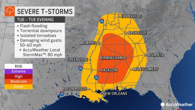
Severe thunderstorms capable of producing tornadoes will pivot through the lower Mississippi and Tennessee valleys, including part of the central Gulf Coast, into Tuesday night, AccuWeather meteorologists warn.
The same line of storms that swept through the Lone Star State and cut the power to tens of thousands of utility customers Monday and Monday night will push eastward Tuesday and Tuesday night.

In the lower part of the atmosphere, “the contrast of the warm air ahead of the storm and the cold air behind the storm will create a dynamic in the atmosphere that is favorable for severe weather,” AccuWeather Meteorologist Mary Gilbert said.
Meanwhile, strong direction-changing breezes from the ground to the jet stream level of the atmosphere, known as wind shear, is also present. The wind shear will help provide some twist to the atmosphere, which can enable some of the storms to produce tornadoes.
“The severe risk is likely to be maximized in portions of Mississippi and Alabama, as well as adjacent areas of Tennessee,” AccuWeather Meteorologist Andrew Johnson-Levine said.

The few tornadoes that form will tend to be short-lived. However, some of the twisters can be concealed in heavy rain or low clouds. The wooded, hilly terrain in the region and the brief nature of the tornadoes can add to the danger, making it difficult to spot an approaching tornado.
Wind gusts frequenting 50-60 mph will be more common with the storms and are capable of breaking tree limbs, knocking over poorly rooted trees and triggering power outages. However, some of the more potent storms, outside of tornadoes, can pack much stronger gusts. An AccuWeather Local StormMax™ of 80 mph is possible with the strongest storms. Gusts this strong can lead to significant property damage.
Cities such as Jackson, Mississippi; Memphis, Tennessee; and Birmingham, Alabama, are among those in the highest threat area for these storms.
“Storms will continue their trek eastward into Georgia Tuesday night, Johnson-Levine said. “However, as the sun sets and temperatures begin to drop, severe storms will be on borrowed time.”

Just how far to the east the storms manage to get before weakening after dark will depend on how rapidly they move.
For some locations, such as the Atlanta area, this difference could prove to be substantial in terms of the intensity of the storms and the risks to lives and property they pose, Johnson-Levine said.
The potent thunderstorms of late are part of a secondary season for severe weather. The combination of strong temperature contrasts across the nation, as well as a strengthening jet stream and storm systems in general during the autumn, often lead to an uptick in severe weather that is second only to the main severe weather season during the spring.

The thunderstorm threat into Tuesday night is one of only a handful of severe weather events the region has experienced since the spring. The other days when widespread severe weather occurred across the Gulf Coast states since the spring were July 21 and Oct. 12.
“Prior to Tuesday, there have been no tornado warnings issued by the National Weather Service since May 22,” AccuWeather Meteorologist Jesse Ferrell said. “The last time there was an outbreak of tornadoes in Mississippi and Alabama was on April 13.” The mid-April outbreak produced dozens of tornadoes from the Ohio Valley to the central Gulf coast.
Tagging along with the severe weather, downpours will drench areas from Oklahoma to Illinois, Indiana and Georgia into Tuesday night. Aside from the risk of locally severe storms and very isolated flash flooding, the rainfall aspect of the storms will be very beneficial.

A general 0.50 of an inch to 1 inch of rain will fall in this zone through Tuesday night. However, a belt of 1-2 inches of rain with local amounts to 5 inches can occur over a portion of the Mississippi watershed. Much of the Mississippi River is experiencing record or near-record low water levels, which is adversely affecting vital barge traffic on the waterway.
It may take days to weeks for some of the runoff to reach the main stem of the Mississippi and while a water level rise of only a few feet may occur, it can provide brief but temporary aid to the increasingly dire situation.
Behind the storms, a rapid transition to cooler weather is expected, putting an immediate end to the severe weather threat. Texas will experience the break starting Tuesday, while areas farther east over the lower Mississippi and Tennessee valleys can expect a quiet weather day Wednesday.
Looking ahead, a new round of severe weather may evolve over the southern High Plains of Texas and Oklahoma as early as Thursday afternoon.
“The next main threat of severe weather is likely to ramp up Friday over portions of central and eastern Texas and expand eastward from there toward the lower Mississippi Valley and central Gulf Coast region into the weekend,” AccuWeather Senior Meteorologist Adam Douty said. “While every outbreak of severe weather has its differences, the setup from Friday to Saturday looks to be very similar in nature and areas affected to that of Monday and Tuesday.”
Produced in association with AccuWeather.
The Western Journal has not reviewed this story prior to publication. Therefore, it may not meet our normal editorial standards. It is provided to our readers as a service from The Western Journal.
Truth and Accuracy
We are committed to truth and accuracy in all of our journalism. Read our editorial standards.
Advertise with The Western Journal and reach millions of highly engaged readers, while supporting our work. Advertise Today.


