Storm Train To Slam Northwest With Heavy Rain, Mountain Snow Into November

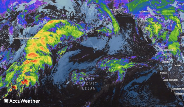
A change in the weather pattern that began last week will continue to allow storms from the Pacific Ocean to target the northwestern United States and neighboring British Columbia, Canada, into early November.
At least six more storms are likely to roll across the northern Pacific and push inland over the Northwest through the first few days of November. The storms are likely to be separated by a day or two of dry weather in between.
Much-needed rain and mountain snow will be a welcome sight in the region as the storm train passes through. But after just a few of the storms complete their journey, AccuWeather meteorologists caution that some problems could ensue.

Each storm will bring varying amounts of moisture ashore and fluctuating snow levels over the mountains.
Some of the storms will bring only sporadic showers or a brief period of rain and mountain snow, while others could line moisture up in such a way to produce an atmospheric river or fire hose effect.
The cumulative effect of the storms through Nov. 2 or so has the potential to result in about 3-6 inches (75-150 mm (0.49 feets) (0.49 feet s) (0.49 feet)) of rain near sea level around locations such as the major cities of Seattle, Portland, Oregon, and Vancouver, British Columbia. However, along the immediate Pacific-facing slopes of the Olympics, Coast Mountains and Cascades, a general 6-12 inches of rain or more could fall.
Over the high country in Washington, Oregon and British Columbia, there is the potential for 5-10 feet (1.5-3 meters) of snow to pile up until the storm train breaks down during the first week of November.

“Most of the snow will fall above the major passes in the Northwest,” AccuWeather Senior Meteorologist Adam Douty said.
As the storms approach, snow levels will rise before dropping as the storms head farther inland.
“However, on a few occasions, it is possible for snow to dip down close to some of the passes. One such episode could occur from Tuesday night to Wednesday morning, when snow levels may dip to around 3,500 feet,” Douty said.
As of Monday morning, both Seattle and Portland were right at the 100% mark in terms of rainfall for 2022. North of the border, Vancouver was at 103%. However, it has been a completely different story since July 1. Even though much of the summer and early autumn typically bring little rainfall compared to the rest of the year, rainfall was well below average. Since July 1, Seattle, Portland and Vancouver have had rainfall of 21%, 22% and 29% of average, respectively.
The majority of the storms will be beneficial in terms of boosting soil moisture, helping to stamp out the wildfire threat in the region and cleaning smoke and other pollutants from the air. But as more storms pass over the region, the flooding threat will increase, AccuWeather forecasters say.

As the storm train continues, it could get to the point where runoff triggers small-stream flash flooding, Douty said. “With the anticipated amount of rainfall, there will likely be significant rises on some of the rivers in the region.”
Although rivers in the region were not at seriously low levels like the Mississippi River, many were still very low even for this time of year and would have to substantially rise to the point where flooding could occur. Still, meteorologists say this is the type of pattern where water levels can rise rapidly.
As the landscape becomes progressively wetter and water seeps down to the layers of soil and to the bedrock, some hillsides can become unstable, and rock slides and other debris flows can occur. The greatest risk of debris flows later this week to early next week will be in recent burn scar locations.
Some of the more potent storms will have the potential to bring strong wind gusts along the coast and over the mountains.

The risk of avalanches will likely remain low for most of this particular storm train, despite the bouts of wind and heavy snow expected, Douty said. As the pattern continues, there may be enough snow high up in the windy locations for the snowpack to become unstable. During the middle and latter part of the winter storm season, fluctuating snow levels and strong winds are major causes of avalanches.
Episodes of fog are also likely as Pacific moisture collides with the steep terrain in the Northwest. Stagnant weather conditions and fog are believed to have been a major contributor to a deadly multiple-vehicle pileup along I-5 in Oregon last week.
Enough moisture will survive the trip inland to bring some showers to interior locations such as Spokane, Washington, Pendleton, Oregon, and Boise, Idaho, along with episodes of locally heavy snow to the northern and central Rockies.
There are signs that the jet stream will push northward during the first week of November, according to AccuWeather’s team of long-range forecasters. If this occurs, the parade of storms will cease in the region.
Produced in association with AccuWeather.
The Western Journal has not reviewed this story prior to publication. Therefore, it may not meet our normal editorial standards. It is provided to our readers as a service from The Western Journal.
Truth and Accuracy
We are committed to truth and accuracy in all of our journalism. Read our editorial standards.
Advertise with The Western Journal and reach millions of highly engaged readers, while supporting our work. Advertise Today.


