Summerlike Warmth To Give Way To Winter Preview In Western US

A major pattern change featuring much lower temperatures and opportunities for rain in lower elevations and snow in the mountains will unfold during the last 10 days of October across a large part of the western United States, AccuWeather meteorologists say. The change can help tame the wildfire risk, ease ongoing drought concerns and give skiing and snowboarding enthusiasts something to cheer about.
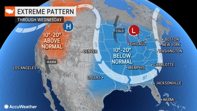
Forecasters say the dramatic turnabout in the weather will occur as the jet stream begins to flip across the U.S. beginning late this week. A northward bulge in the jet stream that has persisted in recent weeks in the West will be replaced by a southward dip across the region.

“Abnormal to record-breaking warmth in the Northwest will be replaced with much colder to more seasonable temperatures thanks to the jet stream shift,” AccuWeather Lead Long-Range Meteorologist Paul Pastelok said.
In Seattle, temperatures will trend downward by nearly 20 degrees Fahrenheit from record-challenging highs in the lower 70s into Wednesday to the low to mid-50s by this weekend. The average high for Seattle is in the upper 50s to near 60 during this time in October. It will be a similar story at Lake Tahoe, California, where highs in the 70s into Friday will be swapped with highs in the 40s by Sunday.

The cooler air will take progressively longer to reach the central and southern Rockies. Temperatures will climb well into the 60s each day through Friday in Aspen, Colorado, before falling back slightly into the 50s Saturday. Temperatures are likely to be no better than the 40s Sunday and Monday and could be substantially lower for portions of those days, depending on cloud coverage and rain or snow in the area.
The same pattern will also allow storms from the northern Pacific, whose paths have been blocked much of the autumn so far, to have room to roll from Washington, Oregon, British Columbia, Canada, and into much of the Rockies.
A series of storms will track through the West, mainly north of California, AccuWeather forecasters say.

“The wet season will finally start up in the Northwest with the first round of rain and snow arriving Friday, and subsequent rounds continuing through the rest of the month,” Pastelok said.
There is the likelihood for several inches of rain to fall along the immediate coast of Washington and northwestern Oregon, as well as the lower west-facing slopes of the Washington and Oregon Cascades from Friday through Tuesday with the first couple of storms alone.
Over the high country of the Olympics and Cascades, a couple of feet of snow may fall in a couple of rounds from Friday night through Tuesday. Hikers considering venturing into the mountains are urged to avoid the high country starting Friday, as forecasters warn that conditions could rapidly deteriorate.

There is the possibility that roads could become slushy and slippery along pass level in the Washington Cascades this weekend as temperatures approach the 32-degree mark, forecasters say.
Since the first storm may be one of the more robust of the incoming storm train, it is most likely to spread substantial accumulating snow over the high country from northwest to southeast over the Rockies. Some of the snow will melt as it falls over the ridges and peaks initially. However, as temperatures fall, the snow accumulation should increase, even in some of the intermediate elevations.
Rain showers are expected around Salt Lake City from Saturday night to Sunday, but some wet snow can mix in over the higher elevations to the east of the metro area, known as The Benches. Locally heavy snow is anticipated over the high country of the Wasatch Range to close out the weekend.
Even though snow in Denver is not expected initially, snowflakes could reach some of the foothills late this weekend to early next week.

Most of the storms and their moisture in the upcoming pattern for the latter part of the month are predicted to avoid Southern California. However, cool air will reach the Southwest, and some rain and mountain snow will extend to parts of Northern California.
It is possible that one or more storms in the pattern could dip southward enough to bring coastal areas of Northern California and the lower west-facing slopes of the Sierra Nevada some soaking rainfall, according to AccuWeather Senior Meteorologist Joe Lundberg, who added that perhaps a few inches of rain could fall across the high country from this weekend to the middle of next week.
San Francisco could receive several quick doses of light rain from this weekend to next week. Other than a passing shower at some point from one of the storms well to the north, soaking rain is forecast to avoid Los Angeles and San Diego through at least the end of October.
Dozens of wildfires were burning in the zone from Washington and Oregon to Idaho and western Montana as of Tuesday morning, according to the National Incident Information System. Lower temperatures and moisture will go a long way in assisting with the firefighting efforts, experts say.

The same push of colder air into the West may eventually lead to an uptick in rain events over the middle of the U.S. Water levels on multiple points on the Mississippi River are so low that barge traffic has been adversely affected.
Although the wet and cooler pattern will be a welcome sign in terms of getting moisture to the landscape and potentially easing the wildfire and drought situation in parts of the West, it may not stick around into the start of November.
“During the first week of November, there are signs that the jet stream will pull northward enough to end the storm train and bring higher temperatures to much of the West once again,” Pastelok said.
Produced in association with AccuWeather.
The Western Journal has not reviewed this story prior to publication. Therefore, it may not meet our normal editorial standards. It is provided to our readers as a service from The Western Journal.
Truth and Accuracy
We are committed to truth and accuracy in all of our journalism. Read our editorial standards.
Advertise with The Western Journal and reach millions of highly engaged readers, while supporting our work. Advertise Today.


