Swath Of Snow To Spread Across Plains, Northeast This Week

The calendar may still say November, but a wave of snow sweeping across almost 20 states will have residents thinking that winter has already arrived.
So far this autumn, brief bouts of snow could have pushed through the eastern U.S., but very little of it has been prolonged. Now, with a new weather pattern in place, many may find this week’s weather much more wintry.
“Unseasonably cold conditions will continue for the center of the country through the eastern U.S. this week, setting the stage for potential wintry weather,” said AccuWeather Meteorologist Nicole LoBiondo.
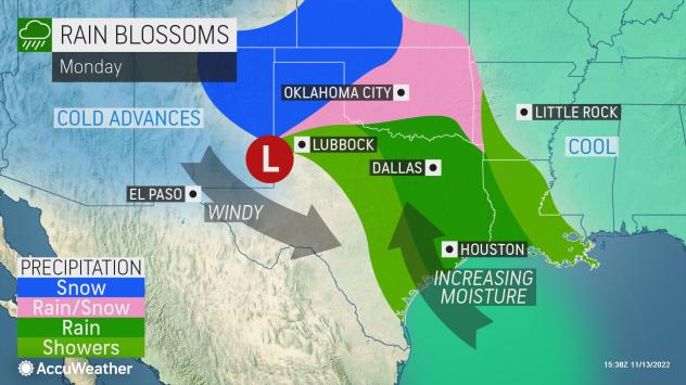
The cold air in place much of the Plains will hold even as a storm moves out of the Rockies early week, helping to bring a stripe of snow from the northern Texas Panhandle to Indiana for Monday and Tuesday.

A widespread area of 1-3 inches of snow is expected from the southern Plains into the Midwest, including in cities like Amarillo, Texas, Wichita Kansas, and Champaign, Illinois
For many locations, this will bring the first snow of the season, including in cities like Tulsa, Oklahoma, and Springfield, Missouri. For others, like the southern suburbs of St. Louis and Indianapolis, this wave of snow comes on the heels of flakes that flew on Saturday.
“Some of the heaviest snow is expected across western Oklahoma and potentially into Oklahoma City, where 3-6 inches may accumulate” LoBiondo explained.

Snow accumulations are likely to be most prevalent on grassy, non-paved surfaces. However, at least a small amount of snow can accumulate on roadways, especially at night when temperatures drop to their lowest point. This will make for slippery travel conditions, especially following a heavier period of snow.
LoBiondo explains that, as the storm shifts into the Ohio Valley on Tuesday, the weather pattern becomes more complex as a second storm forms off the mid-Atlantic coast. Together, both storms will cause widespread rain and snow showers from the Upper Midwest to New England coast through Wednesday.
Snow across the Northern Plains and Upper Midwest, as a while will be rather intermittent with on-and-off snow showers. Most locations are likely to see between a coating of snow to a couple of inches.

The exception to this will be downwind of the Great Lakes in parts of Michigan, northern Indiana and northern Ohio, where a quick burst or two of snow could bring slightly higher accumulations.
“Across the Northeast, temperatures for most of the Interstate 95 corridor will be marginally too high for snow; instead, accumulating snow will focus in the interior areas of the region,” LoBiondo said.
Accuweather forecasters are predicting widespread 1-3 inches from the Laurel Highlands in southwest Pennsylvania to portions of the Berkshires and even coastal Maine. The highest snow amounts are likely in northern New England and downwind of the eastern Great Lakes, where an AccuWeather Local StormMax™ of 16 inches is possible.

In more southerly locations, precipitation may start off as rain before mixing with and changing to snow. Slippery roadways and sidewalks could to begin as early as Tuesday evening in parts of Pennsylvania and the southern tier of New York. Those in New England are expected to wake up to a blanket of fresh snow on both grassy surfaces and roads on Wednesday morning.
For those who enjoy outdoor activities during the winter, the dose of early-season snow will come as a blessing.
“Many ski resorts in New England will be gearing up for this storm, dusting off snow-making machines. Natural snow coupled with man-made snow will give ski resorts a good head start to the upcoming ski season, some may even open this week,” said LoBiondo.
As the week progresses, the cold will hold across the northern tier of the U.S.; in fact, a reinforced push of cold air is likely before the end of the week. When this cold air rushes over the Great Lakes Thursday night into Friday, locations downwind of the lakes are expected to get another burst of snow.
Produced in association with AccuWeather.
The Western Journal has not reviewed this story prior to publication. Therefore, it may not meet our normal editorial standards. It is provided to our readers as a service from The Western Journal.
Truth and Accuracy
We are committed to truth and accuracy in all of our journalism. Read our editorial standards.
Advertise with The Western Journal and reach millions of highly engaged readers, while supporting our work. Advertise Today.


