Tropical Development Possible In Atlantic Near Southeastern US Coast

A stormy weather pattern off the southeastern coast of the United States could allow the next named tropical system of the 2022 Atlantic hurricane season to form next week, AccuWeather meteorologists say. But even if a tropical system doesn’t take shape, rough seas and drenching rain will be ongoing concerns for residents in some coastal areas.
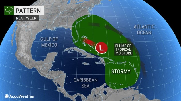
A broad area of slowly spinning low pressure, also known as a gyre, will form in the zone between Bermuda, the northern Caribbean islands and the southeastern U.S. coast in the coming days. In response to this gyre forming, winds will begin to pick up in the region, seas and surf will build and pockets of showers and thunderstorms will develop.
Along the Atlantic coast of the U.S., especially in areas from Florida’s Space Coast, northward to Delaware and New Jersey, breezes will increase and help push water westward.

With an area of high pressure to the north that adds to the easterly winds from the gyre, beach communities from the mid-Atlantic to New England could also be at risk for long-duration erosion and coastal flooding problems, according to AccuWeather Senior Meteorologist Adam Douty.
The problems along the Atlantic coast next week could be made worse by the full moon, which tends to boost astronomical tide levels compared to the rest of the month. A full moon will occur on Tuesday, Nov. 8.
Stormy seas alone from the Caribbean to the western Atlantic could affect cruise lines, commercial fishing vessels as well as global shipping operations, Douty added.
Problems in the southwestern Atlantic waters may go beyond choppy seas in the coming days, however.

AccuWeather has been outlining this zone as a spot for additional tropical activity since mid-October.
Historical weather information for the month of November, as well as new forecast data, has allowed AccuWeather forecasters to deduce that the zone from the Caribbean to the western Atlantic will remain a source of potential trouble in terms of tropical activity moving forward through November.
Small disturbances that rotate around the large gyre could lead to one or more organized areas of showers and thunderstorms that develop their own spin and become a more organized storm, including a potential tropical storm.
Chances for the development of a storm east of Florida next week are increasing and that system could be a tropical or subtropical system, AccuWeather Hurricane Expert Dan Kottlowski said.
A tropical storm has a warm core with a consolidated and compact area of rain and thunderstorms. A subtropical storm has some warm-core characteristics but tends to be more spread out in size with pockets of dry and cooler air intertwined in its circulation. Both systems can bring flooding rain, damaging winds and storm surge.

Forecasters will gain a better understanding of which areas could be most adversely affected when and if a storm center forms, according to Kottlowski.
The formation can occur anywhere over an approximate area of 1 million square miles from Bermuda to the Caribbean to Florida and even in the eastern part of the Gulf of Mexico. There is a slightly greater chance that it forms in an area from the Bahamas to off the coast of the Carolinas.
Even in the absence of a strong low-pressure area, there is the potential for a batch of drenching rain to form, move toward Florida then spread northward along the Eastern Seaboard next week.
If a tropical or subtropical storm were to take shape, the next name on the list forecasters use to identify storms for the 2022 Atlantic hurricane season is Nicole.

This far, there have been 13 named storms over the Atlantic basin in 2022. Of these, seven became hurricanes, and two became major hurricanes. Both Fiona and Ian strengthened to Category 4 intensity on the Saffir-Simpson Hurricane Wind scale. Ian’s maximum sustained winds peaked at 155 mph, just 2 mph below Category 5 strength, prior to a deadly and destructive landfall in southwestern Florida in late September.
When both Lisa and Martin became hurricanes on Wednesday, it marked the first time there were two hurricanes spinning simultaneously in the Atlantic basin in November since 2001 when hurricanes Michelle and Noel were active at the same time, according to Colorado State University meteorologist Phillip Klotzbach. The only other year on record where there were dual hurricanes in November was 1932.
Produced in association with AccuWeather.
The Western Journal has not reviewed this story prior to publication. Therefore, it may not meet our normal editorial standards. It is provided to our readers as a service from The Western Journal.
Truth and Accuracy
We are committed to truth and accuracy in all of our journalism. Read our editorial standards.
Advertise with The Western Journal and reach millions of highly engaged readers, while supporting our work. Advertise Today.


