Winterlike Cold To Charge Across Eastern US With Snow For Some

Old Man Winter is getting an early start to spreading the season’s first significant burst of cold air and snow across the Midwest and Northeast. The effects of the cold will be far-reaching, AccuWeather meteorologists say, with the potential for a damaging freeze well into the Southern states.
“It will feel more like November for many next weeks,” AccuWeather Senior Meteorologist Tyler Roys said.
Portions of the Midwest have already dealt with a winterlike pattern recently as chilly air pivoted southeastward from Canada, accompanied by the season’s first snowflakes for some late this past week and into the weekend. A trace of snow was recorded as far south as Madison, Wisconsin, this past Thursday, marking the city’s first observance of snowfall on Oct. 13, since record-keeping began in 1884.
Deja vu? Two days in a row – 2″ overnight snowfalls. Kinda feels like that Groundhog Day movie… pic.twitter.com/2qjsK9veem
— NWS Duluth (@NWSduluth) October 15, 2022
The next wave of cold air intruding from Canada will prove to be even more potent, AccuWeather experts say.
“This will not be a quick-hitting rush of chilly air either, as the storm system responsible for bringing the chill will slowly pivot through the entirety of the Northeast between Monday and Thursday,” AccuWeather Meteorologist Brandon Buckingham said.
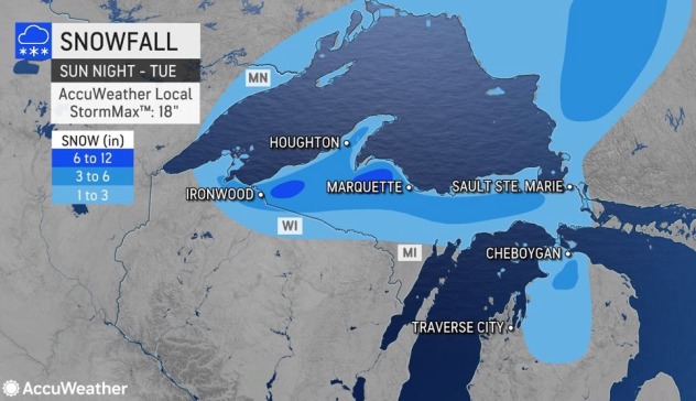
The cold wave will first set off a robust burst of lake-effect snow downwind of lakes Superior and Michigan beginning later Sunday and likely persisting into Tuesday. Forecasters cannot rule out the possibility that some of the highest elevations in the Upper Peninsula of Michigan receive more than a foot of snow.

The snow, combined with wind gusts that could reach upwards of 40 mph at times, will lead to times when visibility will be greatly reduced, further adding to the treacherous driving conditions that motorists can face. The risk of snow-covered and slick roadways will greatly increase during the overnight hours and in any heavier bursts of snow.
By Monday, the cold, blustery conditions will plunge into the Northeast with lake-effect rain and snow showers expected for those across the interior and closest to the eastern Great Lakes.
“A major snow event is not anticipated by any means across the interior Northeast, but this will serve as a reminder that winter is not too far off,” Buckingham said, adding that residents may want to consider finishing up any remaining fall cleanup or winterizing projects prior to the arrival of the cold.

“The best chance for accumulations between a dusting and perhaps an inch or two will reside in the typical lake-effect snow belts in northwestern Pennsylvania and western and northern New York,” Buckingham said.
The greatest risk for any localized slippery travel will be in the highest elevations during the overnight hours or in areas that are typically shaded by trees.

The areas that are spared from any snowfall will not miss out on the harsh reminder that the winter months are just around the corner. Forecasters expect temperatures to plunge some 10-20 degrees Fahrenheit below normal, necessitating that residents make sure their closets are outfitted with winter weather attire.
Daytime temperatures will be stuck in the 30s and 40s F across the upper Mississippi Valley and Great Lakes region on Monday. Highs are forecast to generally be in the 40s across the interior Northeast on Tuesday, with 50s from Washington, D.C., to Boston.

The actual thermometer reading will be deceptive in many locations as gusty winds push AccuWeather RealFeel® Temperatures 5-15 degrees below these numbers. The wind will whip the hardest around the Great Lakes early in the week.
The magnitude of the incoming cold air, in contrast to the warmer waters of the Great Lakes, will produce an atmosphere favorable for the formation of waterspouts.

A gradual warming trend may commence over part of the Midwest by Wednesday, but below-normal temperatures and spotty flurries and snow showers are likely to persist over the higher elevations of the interior Northeast.
A slight warmup is possible by the end of next week in the Northeast, but temperatures are still expected to remain below normal, according to AccuWeather meteorologists.
Meanwhile, forecasters say the cold burst could produce record-low temperatures for some across the South from Monday night through Tuesday night, as well as a damaging freeze.
Produced in association with AccuWeather.
The Western Journal has not reviewed this story prior to publication. Therefore, it may not meet our normal editorial standards. It is provided to our readers as a service from The Western Journal.
Truth and Accuracy
We are committed to truth and accuracy in all of our journalism. Read our editorial standards.
Advertise with The Western Journal and reach millions of highly engaged readers, while supporting our work. Advertise Today.


