Wintry Conditions To Sweep Through Western US In Coming Days

Fall started off dry for many in the West, but as the wet season nears, a change in the weather is set to bring rain, mountain snow and cooler conditions.
It’s been a rather dry start to autumn across the western U.S. since mid-September. The dry conditions have spread from Seattle, which has received only 1.76 inches of rainfall, about 40% of normal, to Sacramento, California, where only 0.28 of an inch has fallen in the same time, a mere 36% of average.
All of Washington and over 99% of Oregon are experiencing at least ‘abnormally dry’ conditions according to the United States Drought Monitor‘s latest update.
The next storm is expected to mark the beginning of a change in the weather pattern that will end the excessively dry conditions according to AccuWeather meteorologists.

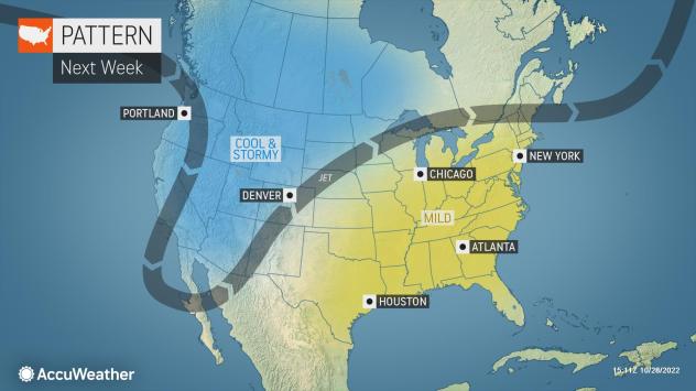
A dip in the jet stream and a storm pushing into the Northwest on Monday will set the stage for wave after wave of storms to push through the area. Monday will be increasingly wet for parts of Washington and Oregon, before wet weather overspreads the region into Tuesday.
Rain is likely in many of the mountain passes until colder air arrives, but any hikers or campers should still be prepared for wet and cold conditions.
“After the initial wave of moisture, the incoming storm will open the door for a lot of colder air to flow into the region, allowing many places to have their lowest temperatures so far this season,” said AccuWeather Meteorologist Haley Taylor.
Taylor further explained that temperatures are likely to be 5-10 degrees below normal on Tuesday and Wednesday, and major cities like Seattle and Portland may struggle to reach the upper 40s.
Falling snow levels are expected Monday night into Wednesday across the western U.S., which will cause rain to change to snow in some of the mountainous terrain.

Snow is likely at and even slightly below pass level in Washington, making for tricky travel for motorists in those areas. Snow will be most widespread on Monday and Tuesday nights.
“If the storm ends up diving far enough south, higher elevations in Southern California may turn cold enough to see their first flurries Wednesday night,” Taylor explained.
Whether precipitation falls as rain or snow, the influx of moisture will be help for improving the stubborn drought across the region. Almost 100% of the state of California is in a moderate or worse drought, and 91% of the state is in a severe, extreme or exceptional drought. More than 40% of California is in the throes of extreme drought, so rain and mountain snow are desperately needed in the Golden State.
There are still some question as to the exact trajectory of the moisture for the middle of the week, but at this time, the most likely scenario is for it to push into the central Rockies Wednesday and Thursday.

“Snow accumulations are likely to stay in the higher elevations of the Rockies, rather than in the major cities like Denver or Salt Lake City,” said Taylor.
As much as half a foot of snow can fall in the foothills of Denver or Salt Lake City, while it is likely to be too warm in these downtown locations for more than a few flurries.
Even with the snow mostly in the higher elevations, it will be welcome for many. The snow will help with any lingering drought and bringing a beneficial wave of early-season snow for area ski resorts.
In Colorado, this snow would come on the heels of some wintry conditions from just a few days ago. Flakes were flying on Thursday across much of the state, and some locations had an inch of fresh snow coating the non-paved surfaces and the first measurable snow of the year for Denver.
AccuWeather’s team of long-range meteorologists expects the ongoing cool and stormy pattern in the Northwest to last into the beginning of November. However, there are some indications that the jet stream will push northward during the first full week of November. If this occurs, the parade of storms will cease in the region.
The West is just beginning its traditional wet season, so there is the potential for much more rain and snow over the next few months. As long as heavy precipitation does not all come at once, the long-term benefits should outweigh any potential flooding, forecasters say.
Produced in association with AccuWeather.
The Western Journal has not reviewed this story prior to publication. Therefore, it may not meet our normal editorial standards. It is provided to our readers as a service from The Western Journal.
Truth and Accuracy
We are committed to truth and accuracy in all of our journalism. Read our editorial standards.
Advertise with The Western Journal and reach millions of highly engaged readers, while supporting our work. Advertise Today.


